


1735 French Expedition to Measure Earth - Part II
...No sooner had I swilled my last sip of white Burgundy when it was replaced by a glass of red Saumur. Another Chef’s selection, meant to accompany my plat (main dish) of duck breast from Challans, a town in the Vendée region of France famous for its poultry. The Uber-Mensch ordered the shoulder of lamb, and both dishes were brought to the table by the Chef Christophe himself. After we ooohed and ahhhed for half-a-dozen sumptuous bites, offering each other a sample portion and then reneging again, it was time to resume the story of the greatest scientific expedition the world had ever known (see Part I here)…
 On May 16, 1735, Charles-Marie de La Condamine and a team of eight scientists, a doctor sent to care for the group, and a botanist, Joseph de Jussieu, set sail for Peru from La Rochelle, France. Their overt mission was to measure one degree of the arc of the earth's meridian at the equator...
 ...Their covert mission was to penetrate the area of the world that had been controlled by Spain for more than two centuries. Click on the map, left, to view how the map of South America changed from the 1700's, after the French expedition.
The easiest part of the journey was the ocean passage from France to the Americas. The seas were calm, the weather cooperative, and the boat equipped with fine brandy. The French team crossed the Atlantic in less than one month. From that point on, however, hardship reigned.
They put in at Cartagena, a swampy and windless port so rife with mosquitoes that some of the team arrived in the New World already sick with fever. They were stricken by the “illness of Siam” -- later known as malaria -- a disease considered dangerous even for the American natives. The victims' strength would ever after be compromised; they would be plagued by fevers for the rest of their lives.
Once in Cartagena, the team needed to reach their starting point in Quito. To do this they had first to cross the Panamanian isthmus, continue south along the continent’s western coast, and travel inland, up and over the western ridge of the Andes Mountains, dragging their telescopes and other heavy, delicate instruments with them all the way. On this leg of the journey they encountered widely varied terrain...
 They coursed swift-moving rivers lined with man-eating alligators in flat-bottomed rafts held together with nothing more than the rope-like branches of the liana tree. They traversed land on mules, hacking their way through dense, dark forest with axes and machetes. They scaled mountains higher and more treacherous than expected or imagined, at times inching along narrow ledges that gave way on one side to deep abyss, at other times crossing over profound crevasses on woven bridges that swayed with each tentative step.

They slept in huts on stilts when torrential rains stopped their progress, or in mountain caves the mouths of which iced over at night and had to be broken through in the morning with frozen and bleeding hands.
More than once, when the route became too rough, they were abandoned by their guides. More than once, when the route became too narrow, they had to abandon 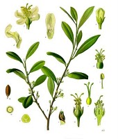 their mules and pack their instruments and belongings themselves. But the worst menace they faced were the insects, whose stings caused painful and fiery itching to exposed hands and faces which swelled and became covered with painful blisters. One by one, the voyagers were brought down by illness and fever. Joseph and the doctor brought them back to life with cures from native plants that their Indians guides taught him along the way. The bark of the cinchona tree they used to create quinine, a tonic capable of reducing high fever. With the leaves of the coca shrub they created a strong analgesic, called cocaine, able to treat pain.
 One year after their departure from France, the team finally made it to Quito. It had taken 11 months to reach the starting point of their expedition. Already bruised and broken, their real work had yet to begin. And what they thought would take two years to accomplish would now drag on for another ten. But when the French scientists finally concluded their measurements and arrived back in France in 1745, they had proven Isaac Newton’s theory the right one.
***
The story, however, does not end there. They didn't all make it back to France. Stay tuned for the rest.
But first, we must ponder dessert…
Sources:
The Great Expeditions. National Geographic, London, 2007.
Whitaker, Robert. The Mapmaker's Wife. Bantam Books, London, 2005.
Images:
Lithograph of Charles Marie de la Condamine, courtesy of Wikimedia Commons.
Map showing changing borders of South American continent from 1700s and onward by Esemono, courtesy of Wikimedia Commons.
Photo of the Andes Mountains by Roman Bonnefoy, courtesy of Wikimedia Commons.
Painting of virgin forest in the South American jungle by Jean-Baptiste Debret, 1834-1839, courtesy of Wikimedia Commons.Drawings of the coca plant, courtesy of Wikimedia Commons.
Satellite photo of the "blue marble" by NASA, courtesy of Wikimedia Commons.
 Post a Comment
.gif)
Reader Comments